| On many of my walks although I have taken
some photos and have had an enjoyable time but I have not gone into detail for
my walking log, If the walk was exceptional I have selected the best photos
and put them on a separate page with a link to them. This has resulted in
many walks being listed without a proper description. I have decided to
create this page which will be my summary page with a brief description
and a few photos if they were taken. A full photo page will be added
wherever it is warranted. |
|
| |
| 404 Miles this
year |
| |
|
17/01/10 Lyme Park circular |
| Walk |
Lyme Park from Disley |
Start
from |
Disley |
|
Distance |
10 miles |
Weather |
Sunny periods |
Walking
time |
5 hours |
Maps |
|
|
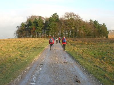
Six of us
from the 40sWalkersNorth met up in Disley for a walk in Lyme Park,
After leaving the village we followed tracks and field paths up
into the park and then across the fields to the Bowstones where
we had elevenses, then it was back into the park and then past The
Cage and back down to Disley. A great day out.
Links
Lyme
Park
40sWalkersNorth
|
|
| |
|
|
|
30/01/10 - Mam Tor and Lose
Hill circular |
| Walk |
Mam
Tor and Lose Hill circular |
Start
from |
Treak Cliff Cavern |
|
Distance |
7 Miles |
Weather |
Sunny periods |
Walking
time |
3 hours |
Maps |
|
|
After
parking at the roadside near Treak Cliff Cavern I climbed up past
The Blue John Mine and up onto Mam Tor, always a great view from
up there. then along the ridge past Hollins Cross and up to the
summit of Lose Hill. After lunch I followed the field paths back
down to Castleton and then back across the fields to my car.
One of my
favourite short walks
Links
Castleton
in the Derbyshire Peak District
Mam
Tor
|
|
| |
|
|
|
05/02/ 10 - High Tove, High
SeatBleaberry Fell and Walns Crag from Ashness Bridge |
| Walk |
High Tove, High Seat,Bleaberry fell
and Walla Crag from Ashness Bridge |
Start
from |
Ashness Bridge |
|
Distance |
8
miles |
Weather |
Cloudy |
Walking
time |
|
Maps |
|
|
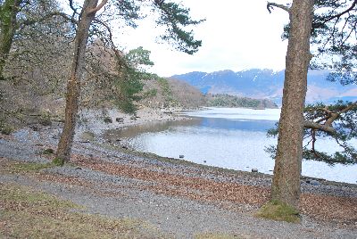
Three of us met up at the Ashness Bridge and
climbed
High Tove, High Seat, Bleaberry Fell
and Walla Crag in very overcast conditions. After the walk it was
onward to the Glaramara Centre for the Annual Get together of the
40sWalkersNorth
Always a
great weekend, 50 walkers attended for plenty of walking, food,
the occasional beer or two in magnificent surroundings
Links
Glaramara Centre
|
|
| |
|
|
|
06/02/10 - Glaramara and
Allen Crags from Seathwaite |
| Walk |
Glaramara and Allen Crags from
Seathwaite |
Start
from |
Seatoller |
|
Distance |
11 miles |
Weather |
Sunny all day, icy fellsides |
Walking
time |
5 hours |
Maps |
Outdoor Leisure 4 |
|
After
leaving the Glaramara Centre at Seatoller we climbed to the
summit of Glaramara in ideal conditions, great views across the
fells, then onto the summit of Allen Crags, we tried to descend
into Langstath but the icy conditions necessitaed a change of
direction so we retraced our steps back to Esk Hause and then down
to Styhead Tarn and back down to Seathwaite and Seatoller
Links
The
weekends walks from Glaramara
|
|
| |
|
|
|
07/02/10 - Dale Head from
Seathwaite |
| Walk |
Dale Head from Seathwaite |
Start
from |
Seatoller |
|
Distance |
7 miles |
Weather |
Overcast |
Walking
time |
|
Maps |
Outdoor Leisure 4 |
|
|
|
|
14/02/10 - Circuit of Chatsworth
from Bakewell |
| Walk |
Circuit of Chatsworth
from Bakewell |
Start
from |
Bakewell |
|
Distance |
10 |
Weather |
|
Walking
time |
|
Maps |
|
|
|
|
|
21/02/10 - Shutlingloe and
Macclesfield Forest circular |
| Walk |
Shutlinslow and
Macclesfield Forest circular |
Start
from |
Trentabank Reservoir |
|
Distance |
5 miles |
Weather |
Clear,cold and icy |
Walking
time |
|
Maps |
Outdoor Leisure 24 |
|
After
parking by the Trentabank reservoir we walked up through
Macclesfield Forest and then across the moors to Shutlingsloe
returning through the forest and back to the car, a great short
walk for an afternoon
|
|
| |
|
|
|
27/02/10 - Chee Dale and
Wormhill circular from Topley Pike |
| Walk |
Chee Dale and
Wormhill circular from Topley Pike |
Start
from |
Topley Pike |
|
Distance |
7 |
Weather |
|
Walking
time |
|
Maps |
|
|
|
|
|
28/02/10 - New Mills to
Buxworth circular |
| Walk |
New Mills to Buxworth circular |
Start
from |
New Mills |
|
Distance |
5 Miles |
Weather |
Sunny periods |
Walking
time |
2½ |
Maps |
|
|
After
parking near New Mills Station we walked along the canal towpath
and then down past Torrs Park and onto the Goyt Way, along side
the river and then up through the fields to Bugsworth Canal Basin,
after a spot of lunch we returned to new Mills by the canal
towpath
Links
The Goyt Way
|
|
| |
|
|
|
06/03/10 - Lancashire -Garstang |
| Walk |
The Brock Valley near Garstang |
Start
from |
Garstang |
|
Distance |
12 miles |
Weather |
Sunny periods |
Walking
time |
5½ hours |
Maps |
|
|
Organised by
the 40sWalkersNorth
14 members of
the 40sWalkersNorth met up in Garstang for a walk in the
surrounding countryside. We left the village and walked along the
canal towpath and then into the Brock Valley. After about 4 miles
we followed the Oakenclough road to Calder Vale and then
across the fields back to Garstang
Another
great walk with the 40sWalkersNorth
Useful links
40sWalkersNorth
|
|
| |
|
|
|
13/03/10 - Lake District - Borrowdale |
| Walk |
Lake District - Borrowdale |
Start
from |
|
|
Distance |
10 |
Weather |
|
Walking
time |
|
Maps |
|
|
|
|
|
21/03/10 - Millers Dale to Monsal Head circular |
| Walk |
Millers Dale to Monsal Head circular |
Start
from |
|
|
Distance |
7 |
Weather |
|
Walking
time |
|
Maps |
|
|
|
|
|
27/03/10 - Snowden circular walk from Plas
Gwynan |
| Walk |
Snowden circular walk from Plas
Gwynan |
Start
from |
Plas Gwynant |
|
Distance |
10 miles |
Weather |
Overcast then sunny periods |
Walking
time |
5 hours |
Maps |
|
|
27/03/10 -
Several of us from the 40sWalkersNorth climbed Snowdon from the Plas Gwynant
Car Park. We left at just before 1000hrs and climbed up to the Bwlch Cwm
Llan and then along the ridge to the summit of Snowdon. Alas the new Cafe
was closed, not a lot of use to us mountain walkers if its not even open on
a cloudy Saturday. Good job we are always self sufficient. We then descended
via the Watkin Path which was very busy with walkers. As we got lower the
cloud lifted and we had excellent views of Crib Goch and Yr Lliwedd. We
arrived back at the car at 1530hrs. A good day out of around 10 miles
|
|
| |
|
|
|
03/04/10- A circular walk on
Kinder Scout from Barber Booth |
| Walk |
A circular walk on
Kinder Scout from nether Booth |
Start
from |
Barber Booth |
|
Distance |
10 miles |
Weather |
Sunny periods |
Walking
time |
6 hours |
Maps |
|
|
A walk up onto the Kinder plateau from Nether Booth then a
turn eastwards and a visit to Madwomans Stones and back over Kinder Scout to
Nether Booth
|
|
| |
|
|
|
10/04/10 - Circular walk from Barber
Booth to Kinder Downfall and Kinder Gates |
| Walk |
Circular walk from Barber Booth to
Kinder Downfall and Kinder Gates |
Start
from |
Barber Booth |
|
Distance |
13 miles |
Weather |
|
Walking
time |
7
hours |
Maps |
|
|
Started from the layby
between Barber Booth and Upper Booth and climbed up onto the Kinder Plateau
by Crowden Clough and then followed the path across to Kinder Low and then
onto kinder Downfall where I had lunch, the return was by Kinder Gates and
then across the plateau and back down Crowden Clough.
A real slog across the
plateau but quite rewarding finding your way across all the peat bogs
|
|
| |
|
|
|
02/05/10- Millers Dale to Monsal
Head |
| Walk |
Millers Dale and Monsal Head |
Start
from |
Ravenstor |
|
Distance |
6 miles |
Weather |
Sunny periods |
Walking
time |
3 hours |
Maps |
|
|
After
parking near the Youth Hostel at Ravenstor I followed the river
past Litton Mill and then along past Cressbrook Mill to Monsal
Head and returned by the Monsal Trail and the hillside path above
the Dale
|
|
| |
|
|
|
15/05/10 - Isle of Rum |
| Walk |
Three days of walking on the
Isle of Rum |
Start
from |
Kinloch Castle |
|
Distance |
25
miles |
Weather |
|
Walking
time |
3
days |
Maps |
|
|
A long weekend on the Isle
of Rum organised by members of
40sWalkersNorth
- We met up in Mallaig on the 14/05/10 ready for the 0730hrs
ferry on the 15/05/10 Saturday morning to the Island. We disembarked at
around 0900hrs and our luggage was transported up to Kinloch
Castle where we were staying. Three days of superb walking on
a beautiful island with no traffic
Click here for a full report and
photos |
|
| |
|
|
|
18/05/10 - Backpacking across the
Knoydart |
| Walk |
Across the Knoydart - Inverie to
Glenfinnian |
Start
from |
Inverie |
|
Distance |
30
miles |
Weather |
Sunny periods and occasional low
cloud and drizzle |
Walking
time |
3
days |
Maps |
|
|
One of my favourite places
is the Knoydart in Scotland. This peninsula in the West
Highlands opposite the Isle of Skye is cut of from the UK
mainland roads network, Frequently described as "Europe's last
wilderness" the area is home to a great variety of birds
and mammals, Golden Eagles and Sea Eagles inhabit the
area together with deer and many other wild creatures. The
starting point for the walk is the small village of Inverie
which is home to Britain's remotest pub the Old Forge well
worth a visit for the real ales, excellent food and folk
music. There is also a tearoom, shop, village hall and
accommodation including a camp site and bunkhouse. I arrived
at 1100hrs on the morning ferry from Mallaig and being early
in day I was unable to sample the Old Forge.
My plan was to walk across
the Knoydart and eventually arrive at the main road in the
village of Glenfinnian, a distance of just under 30 miles,
being alone I decided not to climb any of the surrounding
mountains, I just wanted to follow the track and enjoy the
superb scenery and the peace and tranquility of the area. The
first days walk would take me from Inverie to Sourlies where
there is a bothy but I intended to camp, the distance was
around 9 miles, the second day would take me another 9 miles
over to Strathan where I would camp. The final day would take
me to Glenfinnian and the main road where I would catch a
train back to Mallaig. Being a mature person, or to put more
accurately a pensioner, weight was crucial as I occasionally
suffer from a back (disc) problem. Therefore I weighed
everything down to the last gram to ensure I was carrying as
little as possible. I normally use a Vango Sprite 200 which is
just right for me but weighs around 2600 grams but with the
idea of weight saving I bought myself a new small tent
the - Gelert Solo which weighs 1500grams - £26.00 and found it
good value for money- if I was a younger man I would be buying
a Terra Nova or a Hilliberg but at my age £300 is not
sensible, anyway the grandchildren can have the Solo when I
have finished with it, so its not wasted, it would cost me
that for a nights bed and breakfast. |

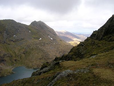
Looking up at the route I will be taking |
|
| |
|
Click here for a full report with photos |
|
|
|
14/06/10 Circular walk from the village of
Flam in Norway |
| Walk |
Circular walk from the village of
Flam in Norway |
Start
from |
Village Harbour |
|
Distance |
5
miles |
Weather |
Sunny
all day |
Walking
time |
2½
hours |
Maps |
|
|
During our weeks cruise
to the Norwegian Fjords the cruise ship the P&O Ventura docked each day in
one of the Fjords. We took the opportunity to either go on a guided walk or
go off and explore on our own. From the village of Flam we took a guided
tour up the valley with a very knowledgeable guide who explained all about
the local fauna and flora together with the local history and customs of the
area.
The weather was good
and the scenery was spectacular
|
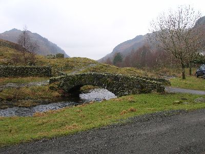
|

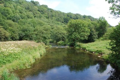
River
Bridge near Flam |
|
| |
|
|
|
15/06/10 Circular walk around the village of
Olden in Norway |
| Walk |
Circular walk around the village of
Olden in Norway |
Start
from |
Village Harbour |
|
Distance |
5
miles |
Weather |
Sunny
all day |
Walking
time |
2½hours |
Maps |
|
|
Today we set off on a
circular walk up the valley from the small village of Olden to a lake a few
miles from the village, we then returned back alongside the river through
some delightful paths across farm fields. Haymaking was in progress
everywhere we went
|
|

Stunning mountain scenery |
|
| |
|
|
|
04/07/10 - Hope and Castleton circular |
| Walk |
Hope and Castleton circular
from Hope |
Start
from |
Road parking near Odin Mine |
|
Distance |
5
Miles |
Weather |
Sunny
periods |
Walking
time |
3
hours |
Maps |
OS
Outdoor Leisure 1 |
|
After
parking at the roadside in Hope the path up the side of Lose Hill
is taken and then halfway up take a path to the left towards and
then through Springhouse Farm, when the trekking centre is reached
turn left into Castleton, after refreshments I took the river path
back to Hope. Always a good short walk for an afternoon.
|
|
| |
|
|
|
17/07/10 - Black Sail weekend |
| Walk |
Black Sail Youth Hostel from
Braithwaite |
Start
from |
Braithwaite |
|
Distance |
25
miles |
Weather |
|
Walking time |
Over 2
days |
Maps |
|
|
Every year the
40sWalkersNorth organises a weekend walk to the Black Sail
Youth Hostel, this year 16 of us were on the walk on the
17/07/10. We started from
Braithwaite near Keswick and followed the Newlands Valley and
then up to Dale Head Tarn, down to Honister Mine and then over
Haystacks and down to Black Sail Hostel. A good evening was
spent at the hostel with great food and a slide show by the
Cockermouth Mountain Rescue Team. Very interesting. The
following morning we crossed Scarth Gap Pass, through
Buttermere and then followed Sail Beck below Knott Rigg and
Ard Crags and then back to Braithwaite. The weather was very
wet and we wisely chose to keep off the high fells. A great
walk with plenty of water gushing down the hillsides. Its hard
to believe there was a hosepipe ban at the time.
Links
Youth Hostel, Black Sail - Travel Information - YHA |

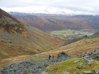
Stormy day on Scarth Gap
Pass |
|
| |
|
|
|
01/08/10 Rudyard Lake circular |
| Walk |
Rudyard Lake circular from Rushton
Spencer |
Start
from |
Rushton Spencer |
|
Distance |
7
miles |
Weather |
|
Walking
time |
3
hours |
Maps |
OS
Explorer 268 |
|
After
parking on the free car park near to the Knott Inn at Rushton
Spencer the walk follows the Staffordshire Way along a disused
rail track for about a mile and then a delightful walk along the
shores of Rudyard Lake accompanied part of the way by the Rudyard
Lake Scenic Railway, upon reaching the dam I crossed over and
after a bite to eat at the cafe the path goes through some
superb woodland before emerging into fields and eventually
rejoining the disused rail track and back to the car. A great
short walk if time is short
The lake is
about 2½ miles long and was built to supply water to the expanding
canal system of the West Midlands
|
|
| |
|
|
|
08/08/10 - Cheedale, Millers Dale and
Wormhill for Topley Pike |
| Walk |
Cheedale, Millers Dale and
Wormhill for Topley Pike |
Start
from |
Topley Pike Car Park |
|
Distance |
8
miles |
Weather |
Sunny
periods |
Walking
time |
4
hours |
Maps |
OS
Outdoor Leisure 24 |
|
After
parking opposite the pay & display car park at Topley Pike I took
the riverside path through the wood past the cottages and on
through Chee Dale, on arriving at Millers Dale I took the path up
to Wormhill and then through Hassop Farm and across the Fields and
back down to the river and back to the car
|
|
| |
|
|
|
16/08/10 Lathkill Dale and Magpie Mine
from Monyash |
| Walk |
Lathkill Dale and Magpie
Mine from Monyash |
Start
from |
Free car park in Monyash |
|
Distance |
10
miles |
Weather |
Sunny
all day |
Walking
time |
5
hours |
Maps |
OS
Outdoor Leisure 24 |
|
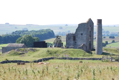
From
Monyash I followed the path from the B5055 into Lathkill Dale
through magnificent scenery surrounded by limestone crags, then up
through the village of Over Haddon where I had my lunch, the path
crosses fields eventually reaching the disused lead mine of Magpie
Mine which was in its heyday in the 1850s. After a brief look
round I headed across the fields and back to Monyash
|
|
| |
| |
|
30/08/10 Cheedale
and Wormhill circular |
| Walk |
Cheedale and Wormhill
circular |
Start
from |
Topley Pike Car Park |
|
Distance |
6
miles |
Weather |
Sunny
periods |
Walking
time |
3
hours |
Maps |
OS
Outdoor Leisure 24 |
|
|
|
|
|
|
18/09/10
Prestbury and Mottram circular |
| Walk |
Prestbury and Mottram circular |
Start
from |
Prestbury Village car park |
|
Distance |
6
Miles |
Weather |
Overcast |
Walking
time |
3 hours |
Maps |
OS Explorer 268 |
|
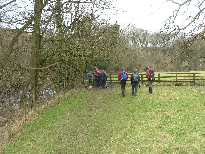
After parking on the free car cark at Prestbury the walk
follows the Bollin Valley Way and then crosses fields to Top o'th Hill Farm
and eventually reaches Mill Lane in Mottram, part of the return route via the Bollin
Valley Way was unfortunately closed due to erosion on the river bank and we
had to divert along Mill Lane and eventually through the grounds of Mottram
Hall Hotel. The path then resumes along the Bollin Valley Way and back into
Prestbury
I am informed by the Cheshire East Council that they are
in discussion with Local Landowners regarding diverting this footpath
around the problem area
There are some lovely buildings in Prestbury and a
beautiful Church
|
|
| |
|
|
|
25/09/10 - Goyt
Valley and the Tors from the Catand Fiddle in Cheshire |
| Walk |
Goyt Valley and the Torrs
from the Cat and Fiddle Inn - Cheshire |
Start
from |
Layby on the A537 |
|
Distance |
10
miles |
Weather |
Sunny
all day with a cold wind |
Walking
time |
4.5
hours - |
Maps |
OS
Outdoor Leisure 24 |
|
Started from a layby just a 100yds west of the Cat and Fiddle Inn, the
weather was fine with a clear blue sky but a rather cold wind. I
followed the track north and down Shooters Clough and past the ruins of
Errwood Hall, then past Errwood Reservoir where I spotted a Cormorant
perched on a marker buoy on the water. Then still heading north through
the forest to Mill Clough and up past Overton Hall Farm where I stopped
for lunch on a delightful bench overlooking the valley. I then climbed
up onto the ridge and walked south past Windgather Rocks, past Pyms
Chair and over Cats Tor and Shining Tor and then back to the car. A
great walk with great views from the high ridge
|
|
| |
|
|
|
02/10/10 -
Circuit of Rudyard Lake near Leek in Staffordshire |
| Walk |
Circuit of Rudyard Lake from
Rushton Spencer in Cheshire |
Start
from |
Rushton Spencer |
|
Distance |
7
miles |
Weather |
Sunny
periods |
Walking
time |
2¾
hours |
Maps |
OS Explorer 268 |
|
After
parking on the free car park near to the Knott Inn at Rushton
Spencer the walk follows the Staffordshire Way along a disused
rail track for about a mile and then a delightful walk along the
shores of Rudyard Lake accompanied part of the way by the Rudyard
Lake Scenic Railway, upon reaching the dam I crossed over and
after a bite to eat at the cafe the path goes through some
superb woodland before emerging into fields and eventually
rejoining the disused rail track and back to the car. A great
short walk if time is short
The lake is
about 2½ miles long and was built to supply water to the expanding
canal system of the West Midlands
|
|
| |
|
|
|
08/10/10-
Sheffield Pike from Glenridding Lake District |
| Walk |
Sheffield Pike from
Glenridding Lake District |
Start
from |
Gillside Campsite,
Glenridding |
|
Distance |
5
miles |
Weather |
Sunny
periods |
Walking
time |
4
hours |
Maps |
OS
Outdoor Leisure 5 |
|
With
several friends we drove up to Glenridding in the Lake District
and pitched our tents at Gillside Camp Site. In the afternoon we
climbed Heron Pike and Sheffield Pike from the camp site. After
lunch on the summit we walked across to Glenridding Mine and back
down the track to the camp site.
In the
evening we spent an enjoyable night in the Travellers Rest Inn in
Glenridding. An excellent meal and great real ale
|
|
| |
|
|
|
09/10/10 - Raise
from Glenridding - Lake District |
| Walk |
Raise from Glenridding -
Lake District |
Start
from |
Gillside Campsite,
Glenridding |
|
Distance |
8
miles |
Weather |
Low
cloud and strong winds above 2000ft |
Walking
time |
5
hours |
Maps |
OS
Outdoor Leisure 5 |
|
After a
good breakfast at the Butty Van on the Camp Site, what a great
idea ! we set off up the track heading for Whiteside, at first
visibility was excellent and we looked forward to some
excellent views on the ridge, however as we got higher the
cloud came down and the wind rose. Once on Whiteside we were
buffeted by strong winds and walking was difficult, we followed
the ridge across to Raise and then down to the Sticks Pass we then
turned east and followed the track back to Glenridding.
An
exhilarating walk with difficult conditions on the ridge
|
|
| |
|
|
|
|
|
|
|
16/10/10 - Mam Tor and
Castleton circular |
| Walk |
Mam Tor and Castleton Circular |
Start
from |
Layby near Mam Tor |
|
Distance |
5
miles |
Weather |
Sunny
periods and showers |
Walking
time |
2½
hours |
Maps |
OS
Explorer OL1 |
|
Time
was limited today and I only had time for a short walk, as I live
in Macclesfield its only a short drive (about 18 miles) to the
start of this walk. After parking in the roadside layby beneath
Mam Tor and next to the Blue John Mine I took the path up the side
of Mam Tor and then along the ridge to Hollins Cross. This ridge
has some of the finest views in the area especially across to the
Kinder Plateau and down into the Edale and Hope Valleys, from
Hollins Cross you can carry on along the ridge to Lose Hill or as
I did on this walk follow the track down to Castleton where there
are many places for refreshment together with several walking
shops. After a break I followed the path out of the village along
the hillside beneath
Peveril Castle and across to
Speedwell Cavern,
then after crossing the road the path crosses the hillside by
Treak Cliff
Cavern and then up to the
Blue John Cavern
and my parked car.
This is an
excellent short walk if time is short and can be completed in most
weathers
|
|
| |
|
|
|
24/10/10 -Circuit of Rudyard Lake
from Rushton Spencer |
| Walk |
Circuit of Rudyard Lake from
Rushton Spencer |
Start
from |
Public Car Park at Rushton Spencer |
|
Distance |
7 miles |
Weather |
Sunny periods |
Walking
time |
3 hours |
Maps |
OS Explorer 268 |
|
A
group of us from our Local Pub "The Bulls Head" at Broken Cross,
Macclesfield met up at Rushton Spencer near Macclesfield for a
Sunday walk, we followed the track south east along the
shore of Rudyard Lake enjoying fine views in nice sunny weather,
after a cup of tea at the cafe by the dam we followed the lake
back along the opposite shore through magnificent woods and then
across the fields and back to Rushton Spencer where we had Sunday
lunch at the Knot Inn. A nice sunday walk
|
|
| |
|
|
|
30/10/10 - Roach End and Gradbach
from Wincle |
| Walk |
Roach End and Gradbach from
Wincle |
Start
from |
Danebridge near Wincle |
|
Distance |
7 miles |
Weather |
Sunny
periods |
Walking
time |
3 hours |
Maps |
|
|
After
parking at the roadside at Danebridge we walked up through the
forest and across the fields to the Hanging Stone, then we
followed the path along the hillside to Roach End, after a lunch
stop we descended the hillside towards Gradbach and along through
the woods to Luds Church, the path then followed the river towards
Danebridge and then back to the car
|
|
| |
|
31/10/10 - Ashford in the Water to
Bakewell circular |
| Walk |
Ashford in the Water to
Bakewell circular |
Start
from |
Ashford in the Water |
|
Distance |
5 miles |
Weather |
Sunny
periods |
Walking
time |
3 hours |
Maps |
OS -
OL24 |
|
After
parking at Ashford in the Water we walked along the pleasant
riverside path and then across the fields to Bakewell, after a
spot of shopping and lunch we returned along the same route. A
nice short walk to a beautiful small town
|
|
| |
|
|
|
|
|
06/11/10- Monsal Head and
Litton circular |
| Walk |
Monsal Head and Litton from
Ravenstor |
Start
from |
Roadside parking by Ravenstor
Youth Hostel |
|
Distance |
7 miles |
Weather |
Sunny
periods |
Walking
time |
3 hours |
Maps |
OS
Outdoor Leisure 24 |
|
After
parking near Ravenstor Youth Hostel we walked along the riverside
through Litton and the Old Mill now converted into timeshare
appartments, then along the riverside path until we came to a
flooded area on the approach to Cressbrook Mill, we took the
alternative path up the hillside and then back down to the mill at
the far side which avoided the flooded area. Then it was along the
lane and up to Monsal Head where we had lunch with superb views
down the valley. Afterwards we walked down to Monsal Head Viaduct
and back along the Monsal Trail, at times high above the river
where the trail avoided the closed railway tunnels. These tunnels
are due to open shortly which will give a great walking and
cycling trail from Bakewell towards Buxton
Useful
Links
The Monsal Trail
|
|
| |
|
|
|
13/11/10 - Croker Hill circular from
Lowerhouse near Sutton |
| Walk |
Croker Hill from Lowerhouse near
Sutton |
Start
from |
Lowerhouse |
|
Distance |
5 miles |
Weather |
Sunny
periods |
Walking
time |
3 hours |
Maps |
Explorer 268 |
|
After
parking at the roadside at Lowerhouse we followed the Gritstone
Trail up Foxbank and along the ridge to the radio mast on Croker
Hill where we enjoyed great views over the surrounding
countryside. After lunch we followed the field paths past
Lower Pethills and back to the car at Lowerhouse. A nice short
walk with good views
Useful
Links
The Gritstone Trail
|
|
| |
|
14/11/10 - Ashford in the Water to
Bakewell circular |
| Walk |
Ashford in the Water to
Bakewell circular |
Start
from |
Ashford in the Water |
|
Distance |
5 miles |
Weather |
Sunny periods |
Walking
time |
2½ hours |
Maps |
|
|
After
parking parking at Ashford in the Water we followed the field
paths alongside the river to Bakewell and after a look round this
loveley small town we returned by the same route
Useful
Links
Bakewell
Ashford in the
Water
|
|
| |
|
|
|
|
|
20/11/10 - Dane Valley and Wincle
from Rushton Spencer |
| Walk |
Dane Valley and Wincle from
Rushton Spencer |
Start
from |
Rushton Spencer Grid Ref
SJ936624 |
|
Distance |
7 miles |
Weather |
Sunny
periods |
Walking
time |
3½ hours |
Maps |
Explorer 268 |
|
After
parking the car at the free car park on the Staffordshire Way
behind the Knot Inn at Rushton Spencer we walked up the lane to
the A523 and crossed over to Tanhouse Lane, this soon became a
track across the fields to join the Dane Valley Way which
follows the Dane Valley Way alongside the River Dane to Wincle.
Lunch was taken at Danebridge and the we followed the path
opposite the Ship Inn at Wincle across to Wincle Grannge and then
down to Dumkins where we joined the Gritstone Trail which we
followed back to Rushton Spencer. An excellent walk with some
great scenery
Useful
Links
The Gritstone Trail
|
|
| |
|
|
|
21/11/10 - A circuit of Mawdsley |
| Walk |
A circuit of Mawdsley |
Start
from |
Mawdsley, Lancashire Grid Ref
SD4999 151 |
|
Distance |
10 miles |
Weather |
Sunny
periods |
Walking
time |
4½ hours |
Maps |
|
|
Today was
the Annual General Meeting of the 40sWalkersNorth and 15 of us met
up at Mawdsley in Lancashire for a walk. We set off from The Black
Bull and followed field paths and lanes in a circular walk around
the village which included Harrock Hill which gave us extensive
views over the West Lancashire Plains, after the walk we held our
AGM followed by a Hotpot Supper.
|
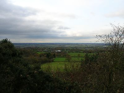
The view over the West
Lancashire Plain from Harrock Hill |
|
| |
|
|
|
28/11/10 - Whaley Bridge and
Bugsworth |
| Walk |
- Whaley Bridge and Bugsworth |
Start
from |
Whaley Bridge |
|
Distance |
5 miles |
Weather |
Sunny
all day with a keen frost |
Walking
time |
2½ hours |
Maps |
|
|
A group of
us met up at Whaley Bridge and walked along the canal towpath as
far as the Torrs Park where we crossed the River Goyt and followed
the Goyt Way and then across the fields to
Bugsworth Canal Basin
where we had lunch, afterwards we followed the towpath back to
Whaley Bridge. A nice short walk with great views across the
frosty fields and canals

|

Whaley Bridge Canal
Basin and Transhipment Warehouse |
|
| |
|
|
|
04/12/10 - Gawsworth and Bosley Locks
circular |
| Walk |
Gawsworth and Bosley Locks
circular |
Start
from |
Gawsworth |
|
Distance |
6 miles |
Weather |
Overcast
with slight drizzle, snow on ground |
Walking
time |
2 hours |
Maps |
OS Explorer 268 |
|
After
parking near Gawsworth Church we followed lanes and field paths
across to the Macclesfield Canal. the weather was overcast with
around 4 inches of snow lying on the fields, we followed the canal
southwards as far as Bosley Locks where we stopped for lunch. Then
we followed the lane west and then north, field paths then led us
northwards back to the car at Gawsworth. A nice short walk with a
little drizzle towards the end
|
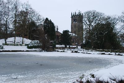
Gawsworth Church over
500 years old, a beautiful church you must visit |
|
| |
|
|
|
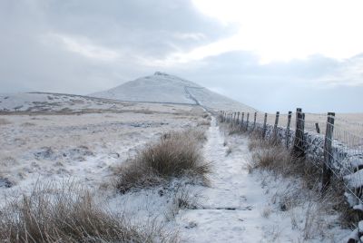
05/12/10 - Mam Tor and Castleton
circular |
| Walk |
Mam Tor and Castleton circular |
Start
from |
Odin Mine beneath Mam Tor |
|
Distance |
5 miles |
Weather |
Sunny |
Walking
time |
2½ miles |
Maps |
Ordnance Survey OL1 |
|
The weather
in Macclesfield was overcast, however I decided to travel across
to Castleton for a short walk. I am glad I did as it turned out to
be a superb afternoon with clear skies, plenty of lying snow and
freezing tempertures. After leaving the car by the Odin Mine just
below Mam Tor I climbed up the hillside past the Blue John Mine,
then after crossing the road I continued up the side of Mam Tor
where eventually the sun broke through and I was rewarded by some
superb views over the surrounding countryside. The ridge to
Hollins Cross was a challenge with deep snow and then I followed
the path down to Castleton which was picturesque with the
Christmas Illuminations - well worth a visit at this time of the
year. As darkness had fallen I followed the road back up to my car
in freezing temperatures. A great afternoon out

|

Mam Tor |
|
|
Looking along the ridge towards Hollins Cross, Back Tor and Lose
Hill |
|
|
|
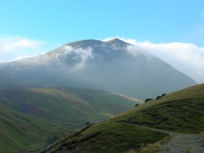
19/12/10 - Shutlingsloe and
Macclesfield Forest circular |
| Walk |
Shutlingsloe and
Macclesfield Forest circular |
Start
from |
Trentabank Reservoir |
|
Distance |
5 miles |
Weather |
Sunny
periods |
Walking
time |
2 hours |
Maps |
|
|
Just a
short walk today as time was limited, after parking the car by
Trentabank Reservoir we walked up through the forest and then
across the open moorland before ascending up the side of
Shutlingsloe, a superb vantage point for the surrounding area,
clear views but very icy underfoot and great care was needed on
the descent then it was back across the moor and through the
forest back to the car
|
|
| |
|
|
|
29/12/10 - Middlewood Way and Macclesfield Canal |
| Walk |
Middlewood Way and
Macclesfield Canal |
Start
from |
Macclesfield |
|
Distance |
7 miles |
Weather |
- Overcast |
Walking
time |
3 hours |
Maps |
-
OS Explorer 268 |
|
A group of
us set out from Macclesfield along the Middlewood Way and walked
to Bollington where we then walked up through the village to the
Clarence Mill and the returned to Macclesfield along the canal
towpath. The canal was still frozen after the recent cold spell
but the temperature was above freezing and everywhere was starting
to thaw out. big change from the minus 10c temperatures we have
endured over the last few weeks. A great post Christmas walk
Middlewood Way
Macclesfield Canal
|
|
|
On the canal towpath near
Macclesfield |
|
|
|
|
|
The last walk of the year, looking back there were many highlights but
the best walk of the year was undoubtedly the crossing of the Knoydart
in May.
Just got to try and ensure that 2011 is even better |
|
|
David
Preston 2010 |
|
Return to Main
Page |
|
|